![[Chronicle]](/images/sidebar_header_oct06.gif)
Vol. 27 No. 4
‘European Cartographers and the Ottoman World, 1500-1750’
Mapmakers perceived, real knowledge of places brought travelers experiences home
By William Harms
News Office
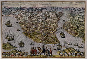 Byzantium Nunc Constantinopolis (from Civitates Orbis Terrarum) George Braun and Frans Hogenberg, Cologne, 1572, 32 cm X 48.5 cm. Bird’s eye view, colored and engraved; Old walled city—Golden Horn Pera, Ushkudar: city views include monuments of Saint Sophia, Topkapi Palace. Twelve vignettes of Ottoman sultans line the bottom margin, including portraits of Soliman the Magnificent and Selim. Numerous ships in Bosphorus and Golden Horn. Mounted Sultan with entourage at bottom center. Leander’s Tower, Yedikule. |
|
An important collection of early printed maps, atlases and sea charts, which trace the changing view of the Ottoman world from the Age of Discovery to the 18th century, will be exhibited at the Oriental Institute Museum from Friday, Nov. 2 through Sunday, March 16.
The exhibition, “European Cartographers and the Ottoman World, 1500–1750: Maps from the Collection of O. J. Sopranos,” is being mounted in conjunction with the Chicago Festival of Maps, a major event beginning this month, featuring exhibits and programs on cartography at cultural institutions citywide.
The exhibition will explore how European cartographers obtained the information that was used for maps and charts of the Ottoman Empire. The era in which the documents were composed (approximately A.D. 1500–1750) will be placed in its context as an age of exploration, when whole new worlds were being opened to Europeans who documented their “finds” in maps.
“The exhibition opens with the intellectual and geographical discoveries of the 15th century that undermined the European medieval view of the cosmos,” said Ian Manners, curator of “European Cartographers and the Ottoman World.” “These discoveries began a process whereby cartographers sought to produce and map a new global geography, one that reconciled classical ideas about the world with contemporary information brought back by travelers and voyagers.”
Among the maps to be displayed are several mariners used as they traveled around the Mediterranean Sea. Others are less utilitarian and are virtually pieces of art meant to invoke an idealized vision of a location.
The interest in the bird’s-eye view of cities, for instance, a theme of many maps, was an effort to make those places visible and vivid to those who remained at home. Many of the maps are embellished with wonders of these foreign lands—images of the Ottoman sultans, sailing ships, people in their native dress and exotic animals.
The exhibition explores major influences on mapmaking, including the rediscovery of the work of Greek cartographers, the development of portolan (navigation) charts, and reports and narratives from travelers and merchants.
“The rediscovery during the Renaissance of the work of Ptolemy, a geographer who lived in Alexandria during the 2nd century, had a profound impact on mapmaking,” Manners said. “Ptolemy used coordinates, in effect longitude and latitude, which was a radical departure from the medieval perspective of maps, which often were shaped by religious beliefs.”
The exhibition explores how that rediscovery influenced the development of maps and also addresses what sort of information—accurate or not—the maps conveyed through graphic forms. It also examines how maps conveyed both perceived and real geographic knowledge of the Ottoman world.
The materials also explain how cartographers managed to convey in their maps information on city planning, architecture, and the locations of natural resources and trade centers. Letters from travelers who recorded their own experiences abroad and whose experiences were incorporated into later maps will be displayed as well.
Most of the material that will be exhibited is from the private collection of O.J. Sopranos. Sopranos’ maps are augmented and complemented by materials from the Newberry Library, the University Library’s Special Collections Research Center and the Walters Art Museum, Baltimore.
“European Cartographers and the Ottoman World” is accompanied by a full color, lavishly illustrated catalogue authored by Manners, professor of geography and Middle Eastern studies at the University of Texas, Austin, and Pinar Emiralioglu, a visiting professor of history at the University of Pittsburgh.
On Saturday, Dec. 8, the Oriental Institute and the Graham School of General Studies will host the symposium, “Mapping the World from Ancient Babylon to the Ottoman Empire,” which will draw speakers from the region and the nation. To register for the symposium, please call (773) 702-9507 or e-mail oi-education@uchicago.edu.