![[Chronicle]](/images/sidebar_header_oct06.gif)
Vol. 26 No. 3
MacAyeal team connects event in Alaska’s Gulf to one in Antarctica
By Steve KoppesNews Office
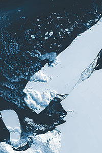 A Landsat satellite image of iceberg B15 in January 2001. The iceberg covered about 11,000 square miles, approximately twice the size of Delaware. Courtesy of Robert Bindschaldler, NASA Goddard Space Flight Center 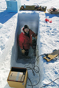 Douglas MacAyeal, Professor in Geophysical Sciences and the College, deploys a seismometer on iceberg C16 in Antarctica. MacAyeal stands in a snow vault, which once covered with plywood and snow blocks, will protect one of his seismometers from the wind. | |
Oceanographers have known for decades that ocean swells can travel half way around the world, but the results of the new study Douglas MacAyeal and Emile Okal released at the beginning of the month and published in the October issue of Geophysical Research Letters, has raised the possibility that an increase in storms driven by climate change could affect far-flung parts of the globe.
A team of scientists who MacAyeal and Okal led have presented evidence in the journal connecting two events that occurred only six days apart but yet at a distance of 8,300 miles from each other. A severe storm that raged in the Gulf of Alaska in October 2005 generated an ocean swell that broke apart a giant iceberg floating near the coast of Antarctica. “One of the things we’re debating in the world right now is whether global warming might increase the storminess in the oceans,” said MacAyeal, Professor in Geophysical Sciences and the College. “The question we then pose is: Could global storminess have an influence on the Antarctic ice sheet that had never been thought of?”
In the study, funded by the National Science Foundation, MacAyeal and Okal, a member of the Northwestern University faculty, reported on a unique seismological signal generated by sea swell when it rocked the iceberg and which was detected by seismometers deployed on the iceberg.
Researchers at the Antarctic Meteorological Research Center at the University of Wisconsin, Madison, who are also part of the research project MacAyeal has been directing, generated daily satellite images that showed on a clear, calm day last Oct. 27, iceberg B15A broke into half a dozen pieces. B15A measures about 60 miles long and 18.5 miles wide. It is half of B15, which became the world’s largest iceberg when it broke away from the Ross Ice Shelf in Antarctica in March 2000.
Over the following years, MacAyeal and co-author Jonathan Thom from UW-Madison had planted seismometers and other instruments on B15A and on the ice shelf to study “iceberg songs” and related phenomena.
“We deployed these instruments to look at a kind of harmonic tremor that the icebergs are making in a way that we still don’t understand terribly well,” Okal said. “We are trying to figure out how the icebergs are sort of making music when various phenomena that we think are linked to the cracking of iceberg masses takes place.”
After the team observed the break up of B15A in satellite images, a crew from McMurdo Station in Antarctica recovered the seismometers for MacAyeal and Okal. The seismometer record showed movement in the iceberg starting 12 hours before it broke up and continuing for three days following. Despite prevailing mild conditions, the iceberg moved half an inch up and down and four inches from side to side. The research team suspected ocean swell as the cause.
If the signal really did indicate ocean swell, the team decided, then there must have been a storm somewhere to create it. The team was able to calculate the distance to the storm from seismometer data by comparing arrival times of the faster-moving long-wavelength waves to the slower-moving short-wavelength waves. To the scientists’ amazement, the storm was 13,500 kilometers (8,370 miles) away.
“Our jaws dropped,” MacAyeal said. “We looked in the Pacific Ocean and there, 13,500 kilometers away, six days earlier, was the winter season’s first really big, nasty storm that developed and lasted for about a day and a half in the Gulf of Alaska.”
The researchers then began uncovering other links of evidence leading from the Gulf of Alaska to the iceberg.
“We looked at the wave-buoy records in Hawaii and Alaska. We saw that the waves in Alaska were about 35 feet tall and then two days later they were down to 15 feet as they passed Hawaii on their way south,” MacAyeal said. And three days after that, a sensitive seismometer on Pitcairn Island in the south Pacific recorded the passage of the storm waves.
“Finally, we see the waves arriving in Antarctica at the site where the iceberg broke up and at several other sites in Antarctica,” he said.
Tiny ocean swells may seem too small to break an iceberg. But the iceberg had run aground near Cape Adare and the Possession Islands in Antarctica before the swell hit. “We think that B15A was in the right position where these waves would be fatal to it,” MacAyeal said.
The experience of B15A appears to be fairly common. MacAyeal and his colleagues also detected other distant storms in Antarctic seismometer records. In fact, the team found that distant storms in the tropics and both the Northern and Southern Hemispheres correlated with all 38 seismological events recorded from December 2004 to March 2005.
“The most impressive event was a typhoon in the Pacific that had been a category five hurricane called Olaf. It produced a very strong reaction on all of our seismometers, so we know that hurricanes do send their waves down to the Antarctic as well,” he said.