![[Chronicle]](/images/sidebar_header_oct06.gif)
Vol. 25 No. 10
Geologists discover unexpected evidence about Tibetan Plateau
By Steve KoppesNews Office
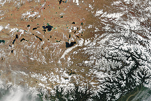 This NASA satellite image from the VisibleEarth Web site at: http://visibleearth.nasa.gov/, shows a portion of the Tibetan Plateau, an elevated region in central Asia sometimes called “the roof of the world.” David Rowley, Chairman of Geophysical Sciences, has studied the region with colleague Brian Currie, and they have found that the plateau has stood at its current high elevation for at least 35 million years. The best explanation for the finding is at odds with a popular theory from the 1980s.  David Rowley | |
Geologists have learned that the height of the Tibetan Plateau, a vast, elevated region of central Asia sometimes called “the roof of the world,” has remained remarkably constant for at least 35 million years.
David Rowley from the University and Brian Currie of Miami University in Ohio reported their finding in the Thursday, Feb. 9 issue of the journal Nature.
Before their last expedition to Tibet, the geologists expected to find evidence that the plateau had been rising 35 million years ago, the result of large-scale geologic forces grinding India and Asia against one another. They found instead that the plateau has stood at its current high elevation for at least 35 million years.
The best explanation for Rowley and Currie’s finding: the plateau has widened progressively northward as the Earth’s crust thickened. “This explanation is at odds with a popular theory that has survived since the 1980s,” said geological oceanographer Chris Beaumont of Dalhousie University in Halifax, Nova Scotia, Canada.
India and Asia began colliding 50 million years ago as a result of plate tectonics, a large-scale geologic force that slowly moves the continents around the Earth’s surface. The collision took place in an area that once may have resembled the tropical Indonesian island of Sumatra, and it produced the Tibetan Plateau. Today, the plateau stretches for 190,000 square miles at an elevation of approximately 16,000 feet.
Some parts of the plateau resemble the terrain of Kansas, said Rowley, Professor and Chairman of Geophysical Sciences. “You could convince yourself that you’re in Kansas, except that you’re breathing a little too hard.”
According to a popular theory, both the Earth’s crust—the planet’s outermost solid layer—and the upper portion of the mantle layer that lies below the crust thicken as the continents collide. Then the crust containing the plateau would have “bobbed up,” Beaumont explained, while the mantle fell away and sank deep into the Earth.
Funded by the National Science Foundation, Rowley and Currie’s research supports the idea that the collision has deformed the crust, but not the mantle. “The bottom of the crust is weak and any attempt to increase the elevation increases the stress on the bottom of the crust, and that crust is now capable of flowing,” Rowley explained.
The Nature paper is based on a technique that Rowley and colleague Ray Pierrehumbert, the Louis Block Professor in Geophysical Sciences and the College, developed in the late 1990s to determine the elevation of ancient land surfaces. “It turns out that elevation is one of the most sensitive monitors of large-scale processes happening within the Earth,” he said.
The technique relies on precise measurement of oxygen isotopes, different varieties of oxygen atoms that are found in rocks formed at various elevations. Water vapor derived from the oceans displays a well-defined isotopic composition that changes in a predictable way, as air masses rise, cool and condense with elevation.
As precipitation seeps into the soil, it becomes incorporated into nodules of calcium carbonate, a chemical compound found in rocks around the world. An oxygen isotopic analysis of these nodules reveals the elevation at which they were created.
The technique is accurate to within approximately 2,000 feet, and it is especially sensitive at elevations of three to five kilometers (9,900 to 16,500 feet). “For asking questions about the height of the Himalayas, the height of Tibet, the height of the Andes, it’s terrific,” Rowley said. “But if you go to small mountain ranges or small elevation differences, you’re probably not going to be able to say much with confidence.”
Previous efforts aimed at reconstructing the elevation history of mountain ranges depended on comparing tree species that live today at various elevations with the species found in the distant past as indicated by fossilized leaves and pollen. But temperature, rainfall and climate change can influence the distribution of tree species, along with elevation. “It’s not always clear which one is the driver,” Rowley said.
As for the Tibetan Plateau, Rowley plans to examine even older rocks to see if he can take a scientific snapshot of the area as it began to rise. From this, scientists will be better able to answer a critical question: how fast does the concentration of heat-generating radioactive elements in thickening crust limit its strength?
“Some people had earlier argued that it took, 10, 20, 30 million years before you got enough heat production to limit that strength,” Rowley said, an argument that his data are beginning to support.
“The significance of this research should not be underestimated,” Beaumont said. “It demonstrates how a critical observation has the potential to advance our understanding of continental deformation.”